
Western Colorado Snowpack Update
Winter is settling in across Western Colorado, and early snowpack totals are beginning to take shape. At this stage of the season, many of our basins remain below average, and the high country will need consistent storms through midwinter to close the gap.
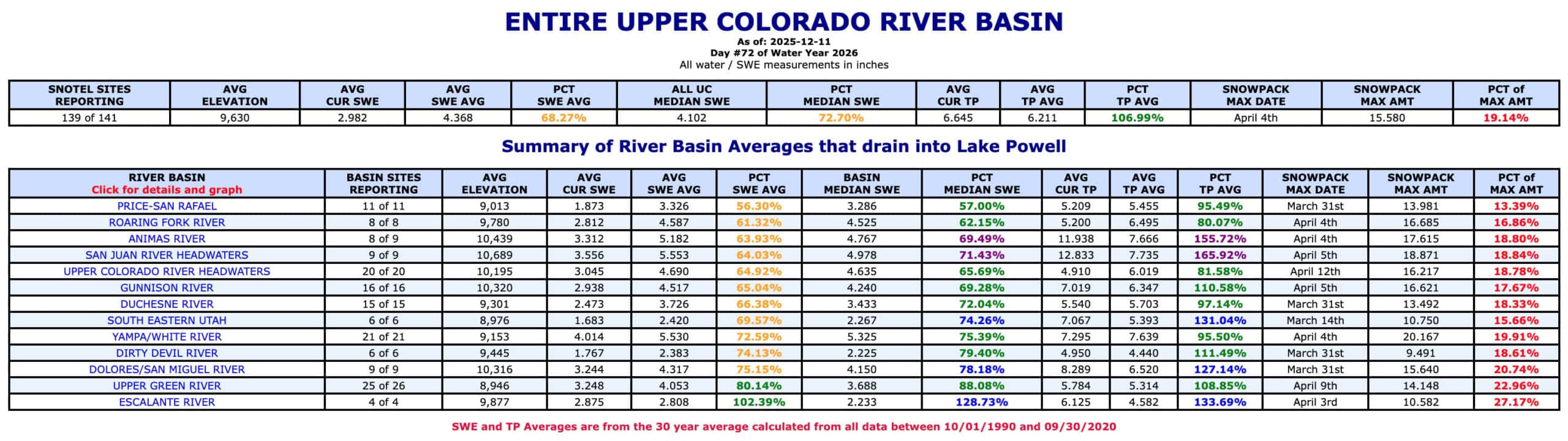
Current Conditions
A stubborn high pressure ridge is currently parked over the Southwest. This pattern is pushing the storm track to the north and limiting meaningful moisture across Western Colorado. As a result, Snow Water Equivalent readings remain below normal for early December. In places like the Roaring Fork basin, snowpack is sitting at roughly half of typical seasonal levels. Across the Upper Colorado and surrounding basins, most SNOTEL sites are running between 50 and 80 percent of average depending on elevation.
What It Means on the Ground
Snowpack is the foundation of water supply in the West. Healthy winter accumulation supports strong river systems, dependable irrigation, and long growing seasons for landowners on the Western Slope. When early totals lag, soils dry more quickly and waterways can feel the strain as we move toward spring.
Variations Across the Region
Some of the high elevation headwaters are tracking closer to where they should be, while lower elevations and southern basins continue to fall behind. These early differences often play out later in the year through uneven runoff and varied streamflows across the region.
Looking Ahead
While the current ridge is keeping conditions quiet, long-range models point to a shift beginning around December 20. A more active storm pattern is expected to take hold as the month wraps up, which increases the odds of a white Christmas for much of Western Colorado. A few well-timed systems could help boost snowpack and set the stage for healthier conditions heading into the new year.