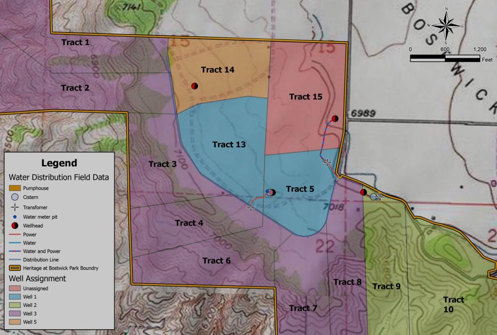
Ranching is rooted in tradition, but the tools guiding it forward are cutting edge. At Eagle Land Brokerage, we are seeing firsthand how digital mapping and data-driven insights are transforming the way landowners manage, protect, and enhance their properties. Through our Land Information Systems (LIS) services, ranchers and land investors are discovering that Geographic Information Systems (GIS) can do more than map a fence line. These tools can unlock the full potential of a ranch.
By visualizing and tracking a ranch’s features and understanding it in detail, GIS information gives landowners the ability to make smarter decisions, increase operational efficiency, and improve long-term stewardship.
Smarter Fencing and Access Planning
Fences define the structure of a ranch, guiding livestock movement, managing wildlife interaction, and marking legal boundaries. GIS allows for highly accurate mapping of existing fence lines and helps identify the most efficient routes for new construction. Instead of relying on outdated surveys or guesswork, landowners can plan fence placements that optimize grazing, minimize maintenance, and improve wildlife management.
The same applies to road and access planning. GIS tools help ranch owners and managers identify the best routes for vehicles, equipment, and livestock movement while avoiding erosion-prone areas and protecting sensitive terrain. These small improvements often lead to significant time and cost savings.
Protecting Habitat and Managing Zones
One of the greatest strengths of GIS is its ability to layer information. With environmental data, landowners and managers can see where critical habitat exists, where vegetation zones overlap. This data is essential for managing land with conservation in mind.
Landowners who want to balance productivity with preservation can use GIS to designate wildlife-friendly zones, manage seasonal grazing rotations, and avoid disturbing ecosystems that they want to conserve. This creates a more resilient and balanced land use strategy that supports biodiversity and long-term land value.
Addressing Erosion and Drainage Challenges
Erosion can be one of the most damaging and expensive problems on a ranch, especially in the varied topography of Western Colorado. GIS can model slope, drainage, and soil types to identify areas at risk before visible damage occurs.
With this data, landowners can proactively install check dams, divert water flow, or re-vegetate key areas. These efforts help protect infrastructure and access roads, preserve the long-term health of the soil, and maintain the land’s ability to support livestock, wildlife and vegetation.
Clarifying Boundaries and Legal Confidence
Unclear property boundaries can lead to legal disputes and costly mistakes. GIS provides a clear, documented visual of property lines, easements, and overlapping claims. This is especially useful in areas with older surveys or irregular boundaries.
For buyers and sellers alike, having a digital map of legal boundaries adds confidence to the transaction. It also helps clarify land use rights, waterways, and existing infrastructure, all of which influence land value and usability.
A Powerful Tool for Modern Ranchers
The future of ranching is not about finding the right balance between the older intuitive knowledge gained by experienced managers and owners and newer technology that serves both the landowner and the land. GIS is a bridge between on-the-ground knowledge and high-level planning. It brings precision to decisions that once relied on experience alone and helps owners build towards sustainable, productive, and valuable ranch operations.
At Eagle Land Brokerage, our Land Information Systems team is ready to help you harness the power of data driven decision making on your land. Whether you’re planning improvements, navigating a purchase, or preparing to sell, we believe smart data leads to smarter land stewardship.
Our LIS program puts actionable insights into your hands, tailored to your land and goals.
Let’s talk about how spatial data can elevate your ranch’s potential.


